Notes from the Field | Thanapan Laiprakobsup and Narongpon Laiprakobsup, Urbanization, Impermeability, and Deteriorating Local Communities in Suburban Bangkok
Bangkok’s suburban areas have been transformed tremendously. Previously, the areas were the most important rice fields for Thailand’s rice production and exports for several centuries. It was the rice bowl of Siam (Thailand’s traditional name). Phongpaichit and Baker (2022 [1995]) argued that the transformation of Bangkok suburban areas began in the 1950s when the authoritarian government led by Field Marshall Sarit Thanarat declared the first Economic and Social Development plan, which aimed to industrialize Thai economy and modernize Thai society to be more westernized societies. The government aimed to transform the local farmlands to be industrial estates to access industrial production and export to Bangkok and eastern ports. Urban housing projects were built for low-income workers who could not afford to rent accommodation in Bangkok’s central business districts. Roads were constructed and replaced waterways for transportation and commutes. By the 1980s and 1990s, urban subdivisions for middle class increasingly replaced rice fields due to city expansion and rural migration. Since the expansion of elevated trains around Bangkok and its vicinities, condominiums and high-level buildings have increased along the elevated railways to serve for urbanites to commute to Bangkok’s center business districts.
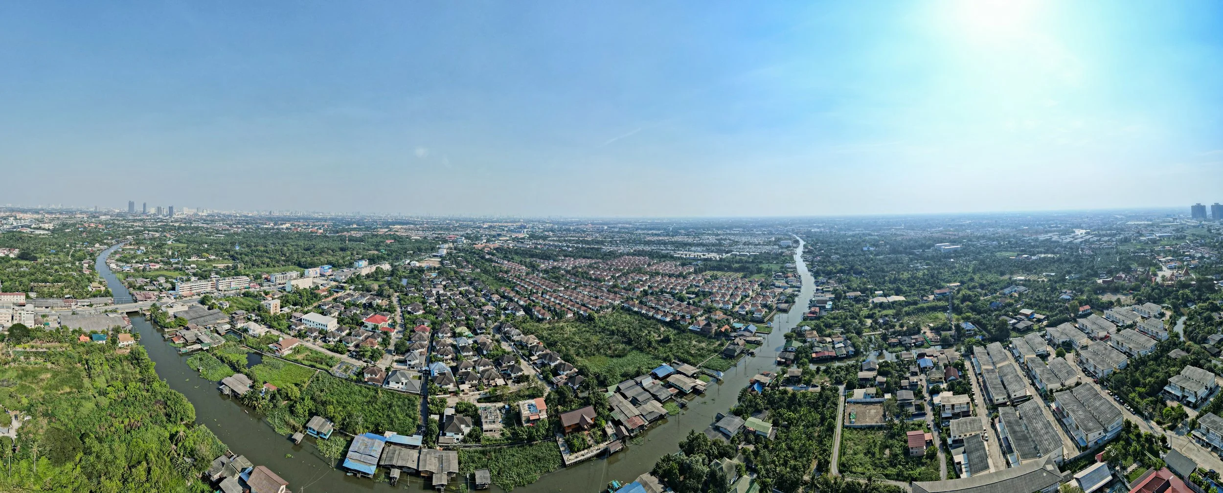
Nonthaburi province has been affected by the expansion of urban communities. It used to be the fruit garden of Bangkok in the eighteenth and nineteenth centuries. The province is now an urbanized province. The green area comprised approximately 41 percent of total land while urban area was estimated 44 percent (Pattanakiat et. al., 2024). The per capita green space has gradually decreased, especially its eastern part which is close to Bangkok. Several public places such as Chinese shrines, Buddhist temples, or float markets have been in decline. Figure 1 illustrates the Bang Phai community, one of the local waterfront communities located along the Om Non canal. According to the figure, the Bang Phai community (in the middle of the picture) is surrounded by urban subdivisions and small-sized industrial estates.
Figure 1: Panoramic View of the Om-Non Canal, Nonthaburi Province
Note: Authors (2023)
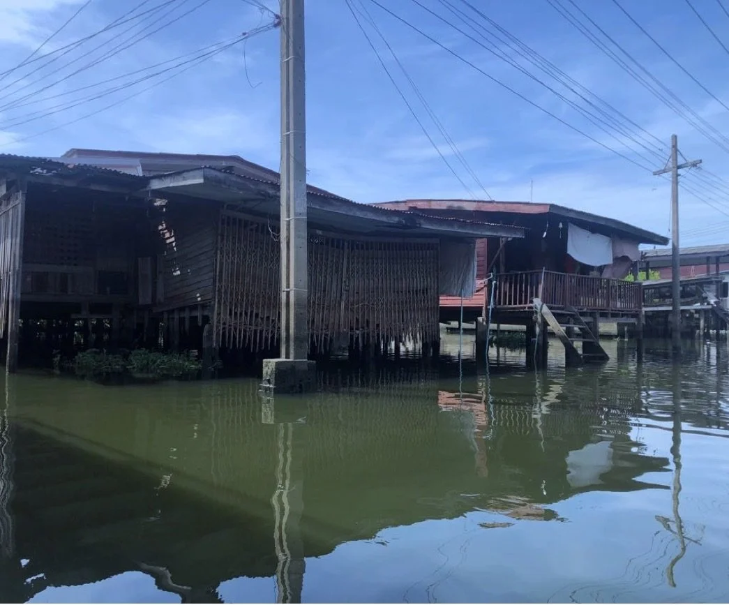
The Om Non canal was once an important waterway which local people used for commuting to Bangkok via boats. Several old communities were established and located along the canal, which could date back approximately 400 years ago. There used to be several local floating markets and community markets where local farmers and merchants exchanged agricultural commodities and sold them to Bangkok markets. The Om-Non canal and its communities have continuously transformed since the 1950s or the beginning of Thailand’s industrialization and urbanization. Expansion of urban subdivisions leads to dislocation of local farmers who cannot afford to rent the land for farming and agricultural production because the land rents rise due to increasing demands. Farmlands have been replaced by urban subdivisions and condominiums while public places such as floating markets have shrunk or disappeared. Laiprakobsup (2023) pointed out that agricultural harvesting has declined since water in the canal was polluted by urban communities’ sewage and industries. In addition, rising temperature from the increase of air conditioning usage leads to climate change in the area so farming and harvesting is unpredictable. Disappearance of local communities and environmental pollution are associated with the expansion of urban subdivisions and industries. Figure 2 shows the impact of urban expansion on local communities around the canal. Picture A represents one of the construction junkyard sites caused by the increase of urban subdivision and condominium projects in Nonthaburi province. Pictures B and C indicate the vacancy of Thai traditional houses in the waterfront communities. According to our boat travelling, there were a lot of deteriorated houses that are left vacant. Several houses are posted ‘For Sale’.
Figure 2: Urban Construction Junkyard and Waterfront Communities in Decline at the Om-Non Canal
Note: a. (Left): Construction Wasteland at the Om-Non canal; b. (center): and c. (right) deteriorating waterfront communities along the Om-Non canal.
According to our boat observation, the most obvious phenomenon in the Om-Non canal and the local communities is impermeability or the back-to-back phenomenon of urban communities invading the local environments and disconnecting with the local communities. Urban subdivisions are more likely to establish close to roads and railways to increase their chance of selling. Therefore, they encircle the waterfront communities which are located near the canal. It becomes very difficult for local people to access roads and railways. The difficulty of accessibility leads to the decline of waterfront communities because local people are more likely to sell their land and move out to other places.
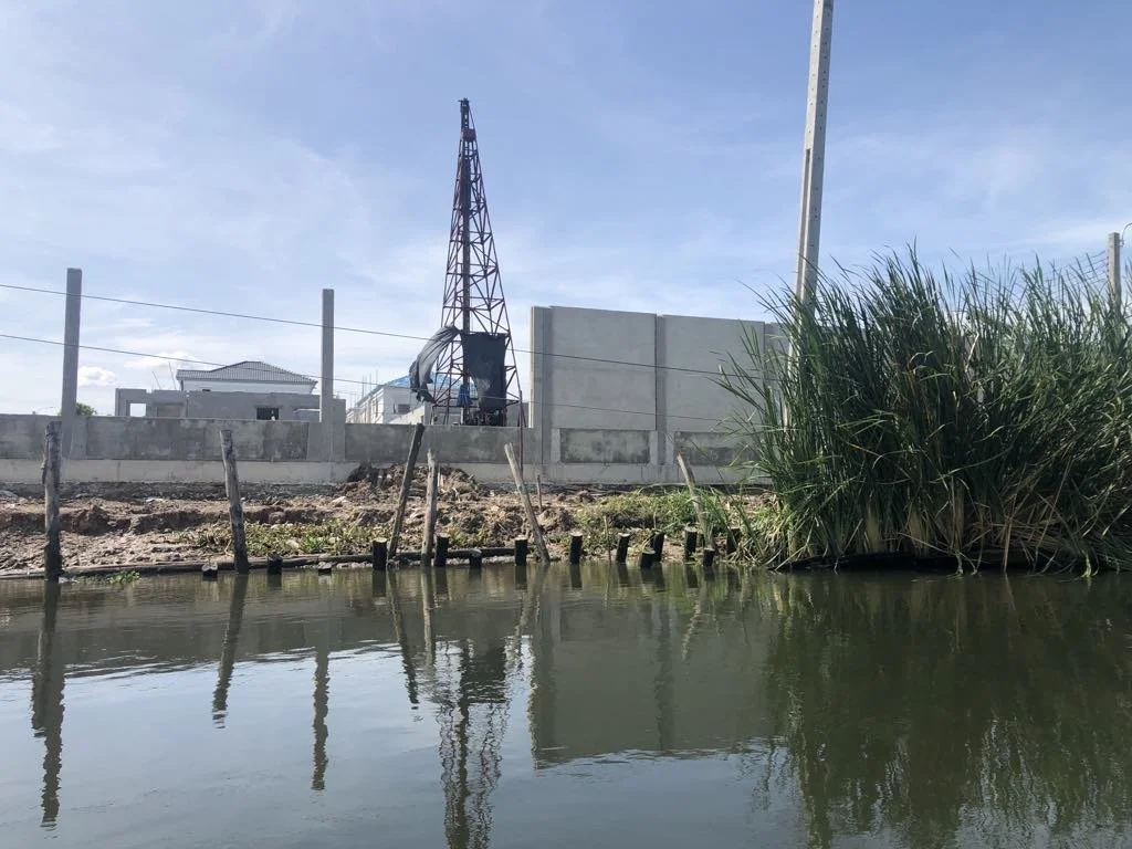
High-level walls indicate the state of impermeability in Bangkok’s suburbs. Since they become estranged and alienated to local communities, real estate businesses usually build high walls against the waterfront communities to protect their subdivisions from local communities. Figure 3 illustrates the building of high walls by real estate at the waterfront. Figure 3 presents the construction of high walls by urban subdivision owners. We observe that the walls are built very close to the waterfront without pathways to access the canal. Building the walls close to the canal impedes the accessibility of local people to access the canal. The public space along the canal is destroyed in that nobody can walk along the canal. In addition, building the walls near the waterfront makes the canal’s bank very steep. Steep banks can make the canal’s wave stronger than it is supposed to be. Stronger canal waves lead to bank subsidence, and the waterfront houses can collapse.
Figure 3: High Wall of Newly Constructed Urban Subdivisions along the Om-Non-Canal
Note: Author (2023)
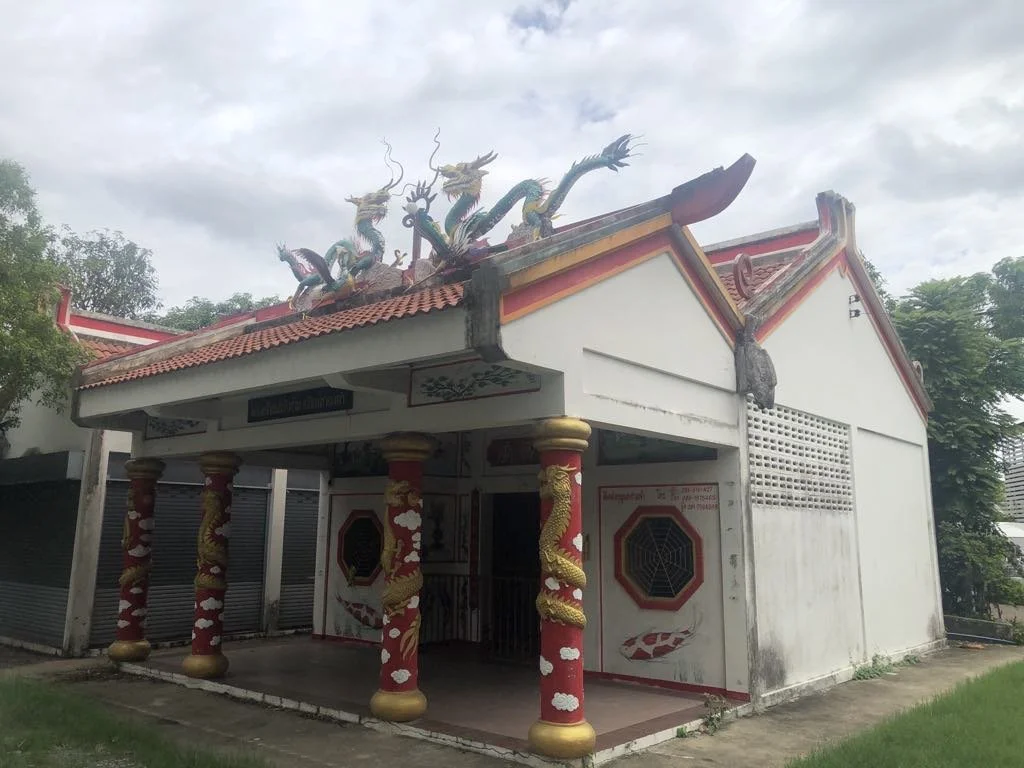
Significant local community landmarks have been deteriorated due to the phenomenon of impermeability. We found that several temples and Chinese shrines have been in severe conditions. Shrines in small communities are severely deteriorated. The Chinese shrine at Bang Phai community is the example of deteriorating landmark due to the expansion of urban subdivisions. Figure 4 illustrates the old Chinese Shrine which used to be the center of the community. Now it is left out and in bad shape. There used to be an important pier for the Bang Phai community with plenty of street food vendors and fleet market when there was Chinese playwright during the Chinese New Moon and New Year. Now, street food vendors and fleet market are gone. Even though the shrine is taken care of by local community’s elderly, the future of the shrine is unstable when the older generation is gone, and the land price increases. The historical root of the community will disappear if the shrine is deteriorated or demolished.
Figure 4: Chinese Shrines Standing Alone Around Urban Subdivisions
Note: Authors
Amphawan temple is another example of a deteriorating local landmark. It is a royal patronage temple which indicates the historical significance of temple. Previously, the temple was the center of the community since there are two important buildings. First, it is the temple’s mondop (i.e. the Buddha’s footprint). The second one is hor trai where the Buddha’s scriptures are conserved. We found that hor trai is not in good condition (Figure 5) meanwhile the mondop’s inside is not sanitary. Even though the temple is a royal patronage, it seems to lose its significance to the local community.
Figure 5: Hor Trai of Amphawan Temple.
Note: Authors (2022)
We cannot avoid the expansion of urban communities and their effects on local communities. But we argue that we can make the communities livable. Urbanites can support local businesses which deliver local tourism and sightseeing. Central and local authorities can help support local businesses and encourage urban tourists to support local communities. Providing incentives (such as tax reduction) for urban tourists who come to visit local communities will encourage the tourists to come and spend time in the communities. Tax exemption for local businesses will sustain the local businesses and services without financial constraints in the long run.
Acknowledgement
This note is part of the project “Potential Analysis of the Waterfront Community Network for Sustainable Development through Sharing Environmental Programs” funded by Thailand Science Research and Innovation Fund Chulalongkorn University (SOC66240006). It is IRB certified by Chulalongkorn University (COA No. 129/66). We would like to thank Kanokkorn Vimolnimit and Parattakorn Intarakamhang for their prompt research assistance.
References
Laiprakobsup, T. (2023). “Urbanization and farmer adaptation in the Bangkok Suburban area.” Kasetsat Journal of Social Science, 44 (2), 387-396.
Pattanakiat, S., Vongvassana, S., Phutthai, T., Nakmuenwai, P., Chiyanon, T., Ratanadilok Na Bhuket, V., Sattraburut, T., Chinsawadphan, P., & Khincharung, K. (2024). “Spatial green space assessment in suburbia: Implications for urban development.” Environment and Natural Resources Journal 2024, 22 (1): 76-92
Phongpaichit, P., & Baker, C. 2002 [1995]. Thailand: Economy and politics. NY, New York: Oxford University Press.
Thanapan Laiprakobsupa, PhD., is Associate Professor of Political Science in the Center of Excellence in Resource Politics and Social Development, Faculty of Political Science, Chulalongkorn University, ASEAN University Network Secretariat (AUN).
Narongpon Laiprakobsup, PhD., is Assistant Professor of Architecture at Kasetsart University.
To cite this essay, please use the entry provided below:
Thanapan Laiprakobsupa and Narongpon Laiprakobsup, “Urbanization, Impermeability, and Deteriorating Local Communities in Suburban Bangkok: An Experience of Waterfront Communities at Om Non-Canal, Nonthaburi,” criticlasianstudies.org Commentary Board, December 11, 2024; https://doi.org/10.52698/MRUC3010.


